Space Technologies for Food Security and Clean Water
- CASSINI Water&Food
Gabriela Quintana Sánchez
- 0
- 12 minutes read

It is estimated that by 2022, between 690 and 783 million [1] people will have suffered from hunger, with an additional 122 million people estimated to have been added after the COVID-19 pandemic. The slow post-pandemic economic recovery has contributed to this increase, in addition to Russia’s war in Ukraine, which depleted the food market in Ukraine.
Unfortunately, global concern is not only due to hunger; access to water, sanitation and hygiene is another basic need and is crucial for maintaining the health and well-being of the population. The water demand is increasing due to rapid population growth, urbanisation, and increased water requirements for agricultural and industrial activities, among others, exacerbated by years of mismanagement, over-extraction of groundwater and contamination of water bodies, and extreme droughts caused by the climate variability facing the planet.
EO for SDG6: Copernicus Water Services and Global Initiatives
Space technologies are tools that contribute to improving food security by optimising land use, supporting yield forecasting and increasing the resilience of the food supply chain. In addition, they can contribute to better planning of access to clean water by identifying groundwater sites, understanding global water cycles, and monitoring and mitigating the effects of floods and droughts. Overall, space technologies have the power to enable humanitarian actors to anticipate better and prepare for future crises.
For the sixth edition of the CASSINI Hackathon, participants with skills to develop products, devices or services that leverage European space data, information and signals from Copernicus and Galileo or future IRIS2 services are sought to enable impactful and sustainable solutions over time.
During this edition, participants will be focusing on topics such as:
– Preventive action for extreme weather events, including impact-based assessments of the food value chain, water supply, infrastructure and communities
– Forecasting and optimization of agricultural yields
– Logistics and resource allocation for emergency humanitarian assistance
– Land cover and land-use monitoring
– Groundwater access and management
– Monitoring water quality parameters such as algal blooms, cyanobacteria, and/or suspended matter.
Here are some application examples:
Arable Land Mapping
Tensions over land use for grazing and agriculture have long existed between communities in central Mali, escalating violence and fomenting an emergency crisis, requiring humanitarian actors to plan their response quickly and efficiently. Mapping farmland is essential to inform such decisions, as it can indicate not only physical security, or lack thereof, but also food security.
The map below is an RGB (Red-Green-Blue) combination of a Sentinel 2 image, whose combination represents maximum values of NDVI (Normalized Difference Vegetation Index – indicator of photosynthetically active biomass) during the first period of the agricultural growing season, representing information on temporal evolution and where cropland can be distinguished from other cover types. The results are derived from comparing Sentinel 2 images of 2017 and 2019.
Built and human settlements, as well as water or rocks, are represented in black (NDVI values are consistently low over time). Natural vegetation appears in shades of grey, due to lower variations of natural vegetation over time, compared to cultivated areas, which appear as rectangles of different bright colours, corresponding to different types of crops, each with a specific vegetation curve over time.
Mapping Land Cover Changes in Refugee Settlements
Uganda has hosted refugees over the years, many of whom have come from Congo, Rwanda and Sudan. While some refugees may return, most remain permanently displaced in the settlements and, with the ongoing political strife in the region, this trend has created a perpetual cycle of emergency response and a growing refugee population in the country, where a very high proportion are women and children. At the end of 2017, after the establishment of Bidi Bidi, refugees and asylum seekers were estimated at 1.3 million people, with almost 986,626 people from South Sudan, 236,406 from the Democratic Republic of Congo and 39,658 from Burundi[4].
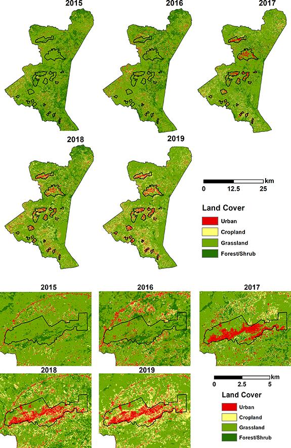
The following map refers to the Land Cover for Bidi Bidi from 2015 to 2019, using Sentinel 2 imagery, where the evolution of residential areas is evident; urbanised areas increased rapidly from 1.8% (2015) to 32% in 2019. Cropland areas stood at only 4.6% in 2015 within the larger settlement boundary, and less than 0.7% within the zones concentrated mainly southeast of the settlement, increased to 5.4% in 2016, with a significant jump to 16.9% in 2019. This rapid expansion of cropland and construction areas coincided with the drastic reduction of natural vegetation from 92% in 2015 to 76.4% in 2019. Shrub/forest decreased to only 7.2% in 2019 from 24.7% in 2015[4].
Groundwater Potential Assessment
Satellite data are tools that complement groundwater prospection studies. Therefore, a variety of geospatial data are required for this purpose, such as:
– Satellite topographic data (e.g., Shuttle Radar Surveying Mission-SRTM and Digital Model Elevation-DEM, TanDEM-X, Sentinel 1)
– Multispectral optical satellite data (Landsat-8, Sentinel 2)
– Airborne or satellite magnetic data
– Synthetic Aperture Radar data (Sentinel 1)
– Precipitation data derived from Meteorological Satellites (such as Tropical Application of Meteorology Satellite-TAMSAT), among others.
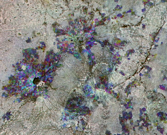
The following is an example of SAR data processing for groundwater prospecting purposes, where a coherence matrix of a four-polarization ALOS-2 scene was obtained, allowing the analysis of individual scattering mechanisms for the discrimination of different surfaces, mainly geological, as part of a groundwater assessment conducted for Kidal, Mali [5].

Satellite data enables us to obtain updated information, generate temporary studies, support the monitoring of refugee camps, and ensure the success and efficiency of humanitarian relief operations. It is necessary to break with the lack of information in many countries to produce updated thematic maps, which promote sustainable development and allow an accurate response to natural disasters, humanitarian emergencies and the maintenance of basic infrastructures. The aim is to encourage the use of satellite data by Non-Governmental Organizations (NGOs) to find solutions to these specific issues, working together with the scientific communities and aid organizations. The sixth edition of the CASSINI Hackathon has the mission to be a connection between these two groups.
Stay updated
For all the latest about the CASSINI Hackathon, visit our dedicated page regularly. Also, visit the official website of the 6th Edition of the Cassini Hackathon.
Reference
[1] FAO, IFAD, UNICEF, WFP and WHO. 2023. The State of Food Security and Nutrition in the World 2023. Urbanization, agrifood systems transformation and healthy diets across the rural–urban continuum. Rome, FAO. Disponible en ttps://doi.org/10.4060/cc3017en
[2] FAO. Clean water and sanitation. Ensure availability and sustainable management of water and sanitation for all. Disponible en https://www.fao.org/3/cc1403en/online/cc1403en.html#/6
[3] Boudinaud, Laure & Orenstein Sacha Alex (2021) ASSESSING CROPLAND ABANDONMENT FROM VIOLENT CONFLICT IN CENTRAL MALI WITH SENTINEL-2 AND GOOGLE EARTH ENGINE. The International Archives of the Photogrammetry, Remote Sensing and Spatial Information Sciences, Volume XLVI-4/W2-2021 FOSS4G 2021 – Academic Track, 27 September–2 October 2021, Buenos Aires, Argentina
[4] Nakalembe, Catherine. et al (2022) Impacts of large-scale refugee resettlement on LCLUC: Bidi Bidi refugee settlement, Uganda case study. Environ. Res. Lett. 17 064019
[5] Burrows, G (2018) Remote sensing, GIS and groundwater exploration. 4th United Nations / Pakistan / Prince Sultan Bin Abdulaziz International Prize for Water International Conference on the use of Space Technology for Water Management.
Featured image credit: Freepik


