EO for SDG6: Copernicus Water Services and Global Initiatives
- Water-ForCE Water&Food
Kacia Rutkoŭskaja
- 0
- 15 minutes read

Earlier this week the Water-ForCE Horizon 2020 project team organised a webinar on Copernicus water services, with a focus on SDG6: Clean Water and Sanitation.

Water Accounting for SDG6
Dr. Marloes Mul from IHE Delft Institute for Water Education presented her work on the relationship between remote sensing, water accounting, and the SDGs. In her presentation she focused on SDG6 indicator 6.4 (water stress and water use efficiency).
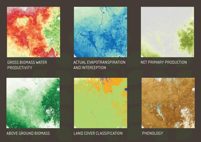
The use of remote sensing data in respect to SDG 6.4 allows:
- Near-real-time data access as well as time series.
- Estimate water consumption of the largest water users (agriculture).
- Access to other products that are available and provide benefits of water use (eg biomass production)
- Simple open data sets (including FAO WaPOR* with a user-friendly portal)
In addition to collecting a dataset, it is important to understand how to translate this data into information. This is where the concept of water accounting can play a key role.
Water Accounting can be defined as the systematic acquisition, analysis and communication of data and information relating to stocks and fluxes of water in natural, disturbed or heavily engineered environments, within a geographical domain.
Water Accounting aims to:
- Collect data and identify data gaps.
- Analyse data from raw data to information.
- Make information available to stakeholders.
Please see the presentation to find out how Water Accounting works and what kind of reports it provides. This presentation includes a list of available resources, scripts, and training materials.
SDG6 and global water quality monitoring
Dr. Deborah Chapman, Ambassador and Former Director of the UNEP GEMS/Water Capacity Development Centre at the University College in Cork, Ireland, shared her work on global water quality monitoring.
Established in 1975, GEMS/Water aims to encourage and support water quality monitoring for the creation and dissemination of reliable water quality data for national, regional, and global users to support effective water resources management.
Developing the global capacity to monitor the quality of fresh water in support of environmental assessments at national, regional, and global scales, is the GEMS/Water key mission.
Dr. Chapman identifies the following challenges for the methodology:
- Has to be useable by any nation worldwide
- Minimal extra monitoring burden for countries
- Meaningful and comparable data
This challenge can be overcome by national governments by using two-tier reports:
- Level 1: Reports based on core parameters only, combined into a water quality index.
- Level 2: Adding more parameters or alternative methods, using additional, local water quality monitoring capacity.
More information is available in the speaker’s presentation.
Space for SDG6: an overview of global initiatives

In his presentation “Space for SGD 6: An Overview of global initiatives”, Mr. Mustapha Iderawumi, Industry Analyst at Space in Africa stated that “Water management is complex, as it requires considerable diverse and accurate data. Space technologies are increasingly used globally in the fight for universal access to safe water and are paramount for the achievement of SDG 6”.
He then introduced a list of global initiatives, which are focused on Space for SDG 6:
- The Space4Water Project, promoting the use of space-based technology for increased access to water.
- Hyperspectral missions, like NASA’s HyspIRI and the Italian Space Agency’s PRISMA demonstrator. These missions offer spatial resolutions of up to 30 m, more frequent revisit times.
- NASA’s Gravity Recovery and Climate Experiment Follow-On (GRACE-FO) projects, in partnership with the German Research Centre for Geosciences (GFZ). The projects intend to test a new technology designed to significantly improve the already remarkable precision of the GRACE measurement system.
“Water sustainability is essential to achieve many of the SDGs,” Mr. Iderawumi said. “Particularly Goals 3, 6, 7, 11, 14, 15 and 17, although there are links to all 17 goals. Similarly, the SDGs heavily overlap. So to realize a positive result for SDG 6, all SDGs must be addressed collectively, as a unit”.
Don’t miss the next webinars!
Water-ForCE organises webinars every last Wednesday of the month. The next online event “Copernicus for Africa” will take place on March 30. All information and free registration are available here.
To stay connected to Water-ForCE, please register your interest here.
Make an impact
The Water-ForCE consortium is defining the future of inland water services for Copernicus. You can help us discover the biggest information needs with regards to satellite remote sensing for coastal and inland water.
Please fill out the Water-ForCE survey here: Fill out the survey.
About Water-ForCE
All six Copernicus Services (Atmosphere, Marine, Land, Climate Change, Security, Energy) deliver water and hydrology-related services. However, the European Commission noticed that this way it is hard to get a comprehensive understanding of the global water cycle, there are gaps in water-related products, there are certain aspects of duplication and it is hard for different user communities to find relevant Copernicus products. Therefore, the Horizon2020 Space Programme had a call for a Coordination and Support Action project: “Copernicus evolution: Mission exploitation concept for WATER” to find the best long-term mission concept.
The “Water scenarios For Copernicus Exploitation” (Water-ForCE) consortium proposed to develop a Roadmap for Copernicus water services. The Roadmap will provide a user and stakeholder-driven concept for water services (water quantity, water quality, hydrological parameters, ice, snow, etc.), by assessing the existing and emerging needs, the opportunities presented by the current and future technical capabilities of satellite and in situ sensors, and addressing the current disconnects between remote sensing, in situ observations and modeling communities. Critically, the Roadmap will deliver the clarity required in relation to the needs and expectations of the core Copernicus mission by the public and private sectors and the wider research and business innovation opportunities.
*FAO WaPOR – The FAO (Food and Agriculture Organization of the United Nations) portal to monitor WAter Productivity through Open access of Remotely sensed derived data


