Illuminating Forced Migration Challenges through Space Technology Insights
- CASSINI
Gabriela Quintana Sánchez
- 0
- 8 minutes read

Forced migrants flee or are forced to leave their homes or places of habitual residence because of events that threaten their lives or safety. They have a special status in international law under the terms of the United Nations Convention and Protocols Relating to Refugee Status.
People may leave their homes because of persecution, human rights violations, repression, political and economic crises, armed conflict and natural or artificial disasters. This definition encompasses those who cross international borders in search of refuge and those who are internally displaced[1].
As a result of these threats, migrants flee such vulnerable areas in search of work to ensure their safety; however, the massive arrival in new places can collapse the supply of essential services estimated by the governments of the receiving countries. According to the current estimate of the United Nations, there were about 281 million international migrants in the world in 2020, equivalent to 3.6% of the world’s population [2].
Exploring Space-Aided Solutions
Space technology can help us understand the impact of the evolution of refugee camps, identify new settlement sites, track land use and land use changes in coastlines, and support planning for designing and delivering humanitarian aid to people in need.
For the 3rd Challenge of the 6th Edition of the CASSINI Hackathon, participants must develop products, devices or services that leverage European space data, information and signals from Copernicus and Galileo or future IRIS2 services to enable impactful and sustainable solutions over time.
During this edition, participants should focus on topics such as:
- Digital tools and big data in migratory processes and population displacements
- Planning, decision making and resource allocation due to anthropic and/or natural disasters
- Transportation and logistics to support displaced communities
- Impact of desertification on rural communities.
- Monitoring of coastal communities and erosion
The following is an example of an implementation study of the Sustainable Development Agenda indicators, particularly those related to Goal 11, “Make cities and human settlements inclusive, safe, resilient and sustainable“. Quantitative indicators should be crucial for understanding this goal, as they provide temporal and spatial information. The adoption of the New Urban Agenda carries concepts related to urban migration, with a constant and solid reference to the respect of the human rights of refugees and internally displaced persons, regardless of their migratory status, and the need to support host cities in the spirit of international cooperation.
Case Study: Addressing Migration Challenges
By 2015, Europe had employed novel techniques to track their walls when more than a million Syrians attempted to enter; being a situation that went beyond just guarding the borders, it was necessary to incorporate an efficient migration policy in Europe.
Quantitative geospatial data then becomes a suitable source for support, which has been the direction indicated by the United Nations Global Geospatial Information Management (UN-GGIM). The spatial dimension of these data covers problems related to spatial concentrations of refugees, health and safety (e.g. from natural hazards), requirements for new services (e.g. transport, schools, hospitals, etc.), the impact of climate change (e.g. droughts, desertification), monitoring of migration flows, among others.
To answer all these multifaceted questions, geospatial data and techniques provide temporal and spatial measurements necessary to assess benchmarks, patterns, and trends and support short- and long-term decision-making.
Below is a summary of the thematic maps generated for the city of Bari, related to the indicators associated with goal 11 of the 2030 Agenda for Sustainable Development, which contributes to better planning and management of refugee settlements,
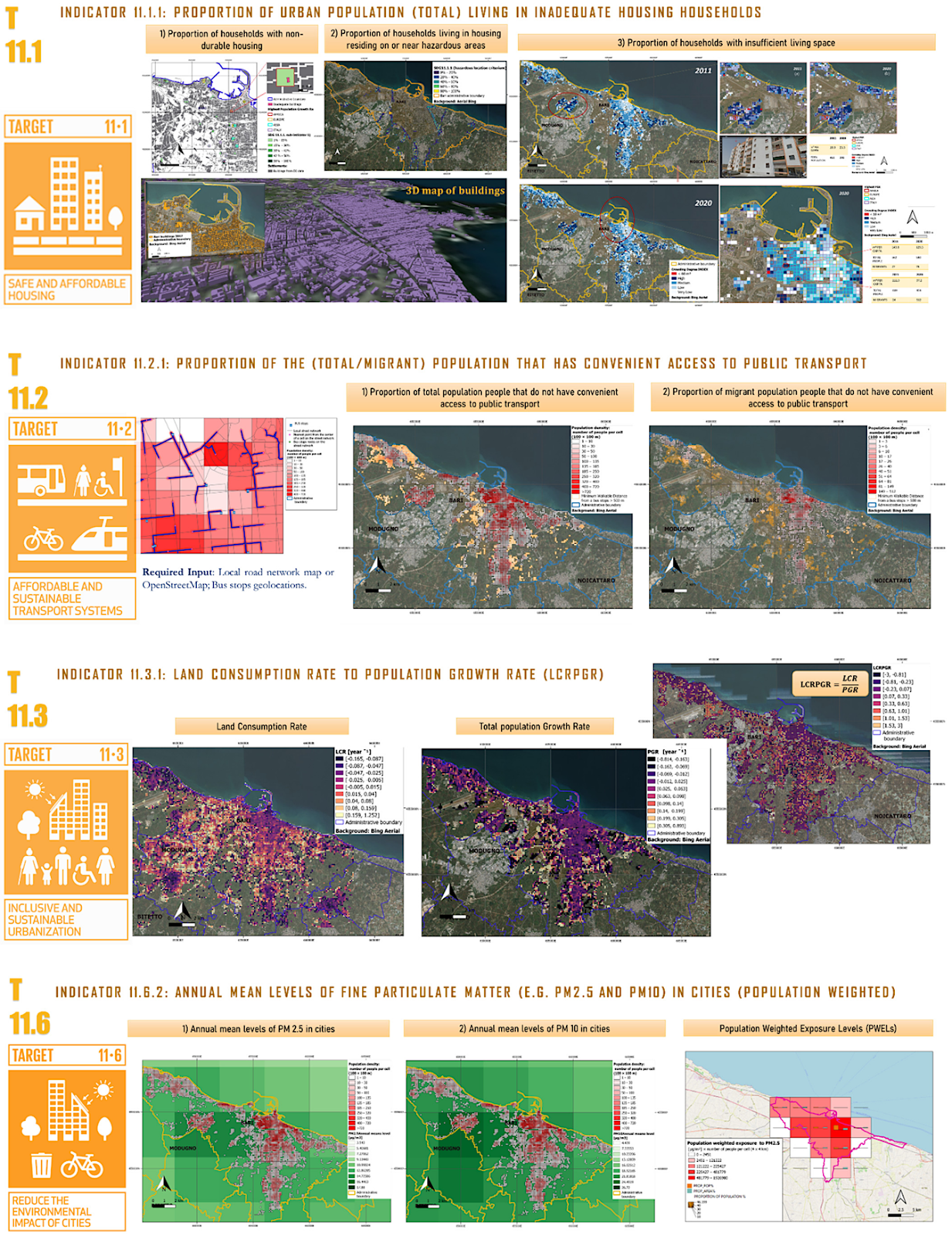
Satellite data enables us to obtain updated information, generate temporary studies, support the monitoring of refugee camps, and ensure the success and efficiency of humanitarian relief operations. It is necessary to break with the lack of information in many countries to produce updated thematic maps, which promote sustainable development and allow an accurate response to natural disasters, humanitarian emergencies and the maintenance of basic infrastructures. The aim is to encourage the use of satellite data by Non-Governmental Organizations (NGOs) to find solutions to these specific issues, working together with the scientific communities and aid organizations. The sixth edition of the CASSINI Hackathon has the mission to be a connection between these two groups.
Stay updated
For all the latest about the CASSINI Hackathon, visit our dedicated page regularly. Also, visit the official website of the 6th Edition of the Cassini Hackathon.
Reference
[1] Martin, S. (2000) Forced migration and the evolving humanitarian regime. Institute for the Study of International Migration Georgetown University Washington, DC-USA
[2] Mcauliffe, M. Y A. Triandafyllidou (EDS.), 2021. Informe sobre las Migraciones en el Mundo 2022. Organización Internacional para las Migraciones (OIM), Ginebra. Disponible en https://publications.iom.int/books/informe-sobre-las-migraciones-en-el-mundo-2022
[3] Aquilino, M.; Tarantino, C.; Athanasopoulou, E.; Gerasopoulos, E.; Blonda, P.; Quattrone, G.; Fuina, S.; Adamo, M. EO4Migration: The Design of an EO-Based Solution in Support of Migrants’ Inclusion and Social-Cohesion Policies. Remote Sens. 2022,14,4295. https://doi.org/ 10.3390/rs14174295
Featured image credit: Freepik


