Avdiívka: Witnessing War’s Impact from Space
- Ukraine
Gabriela Quintana Sánchez
- 0
- 12 minutes read
This February marks ten years since the beginning of the Russo-Ukrainian War and two years since the full-scale Russian invasion of Ukraine. Despite Russia’s plans to “capture Kyiv in three days” in February 2022, Ukraine continues to contain Russian aggression from further spreading on European territory. For two years now, our website has been publishing news on the use of satellite data technologies in this war, from using Starlink to purchasing a SAR satellite with donations. In one of the last publications, we looked at the city of Bakhmut from space. The city has been in the public spotlight as one of the most tense sites of the conflict. Now, we will take a look at another city.
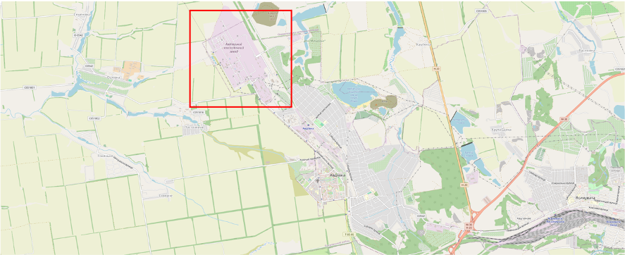
One of the cities heavily affected during this confrontation has been Avdiívka, in eastern Ukraine, which has been the scenery of intense fighting from the beginning, located near the front line between Ukrainian forces and pro-Russian separatists. The fighting has focused on the Avdiívka Coke and Chemical Plant, a major industrial facility of coke (used mainly in iron ore smelting but also as a fuel in stoves and forges), which has been severely damaged. In February 2024, Ukrainian forces withdrew from the city after suffering heavy losses.
The war in Avdiivka has had a devastating impact on the city and its inhabitants, with much of the infrastructure being damaged or destroyed. At the same time, 80% of the residential buildings, schools, hospitals, and factories (e.g., the coke plant) were affected by the fighting, leaving thousands homeless, incapacitated and isolated. Access to clean water, electricity, and natural gas has been severely limited. Thousands of people have been displaced from their homes, causing a humanitarian crisis, with shortages of food, water, and medical care, an uncertain future, and increasingly serious humanitarian consequences.
Relevant events during the fighting in the city of Avdiívka include a Grad missile attack on the coke plant that left ten dead in 2017, during 2020, Russian forces captured several villages, and, by 2022, the city became one of the most fortified cities in the region. At present, Russian forces have taken the city completely, generating devastation and suffering for the population, leading to a humanitarian crisis with serious needs for assistance and damage to the local and regional economy.
Eyes in Space
With the help of satellite imagery is possible to perform continuous monitoring of the conflict and its further effects. The sheer scale of damages can be documented and recorded with different scales of granularity for various areas of interest. As such, the local and regional impact of the conflict on society, environment, infrastructure and human settlements can be evaluated. Once more, Earth Observation proves to be an invaluable tool for modern society by providing vital information about the Earth as a system, from its surface to atmosphere and water cycle:
- Environmental monitoring: allows us to observe changes in vegetation, deforestation, desertification, and pollution.
- Natural Disaster Tracking: detects and monitors events such as droughts, floods, wildfires, and volcanic eruptions.
- Natural resource management: support with land use planning, agriculture, and biodiversity conservation.
- Mapping: support creates accurate and up-to-date maps of the earth’s surface, including topography, roads, buildings, and other elements.
- Urban Planning: support plans for urban growth, infrastructure construction, and traffic management.
- Surveillance and security are used for border surveillance, monitoring of illegal activities, and disaster prevention.
- Military intelligence: allows us to obtain information about enemy forces and movements, as well as to plan military operations.
- Agriculture: are used to estimate crop production and monitor plant health.
- Transportation: support plan transportation routes, optimise logistics, and monitor traffic.
- Insurance: are used to assess risks and assess damages in the event of natural disasters. In short, satellite imagery is a powerful tool that allows us to observe, understand, and manage our planet more efficiently and sustainably.
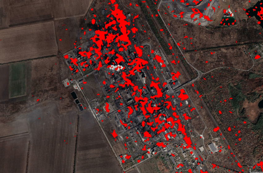
Avdiívka Seen from Space
On 20 January 2024, Russian forces broke through Ukrainian defences in southern Avdiívka, capturing the fortified Tsarska Okhota restaurant and advancing up north. Russian sources reported that the east of Tsarska Okhota and southwest of the previously captured southern industrial zone were taken. Early on 17 February, Commander-in-Chief Oleksandr Syrskyi confirmed that Ukrainian forces were completely withdrawing from Avdiívka to “more favourable lines” as to “avoid encirclement and preserve the lives and health of service personnel”. In the following images, we can see the damage generated during the Russian invasion.
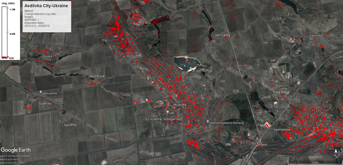
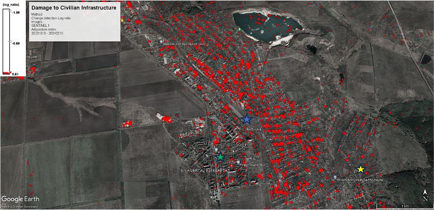
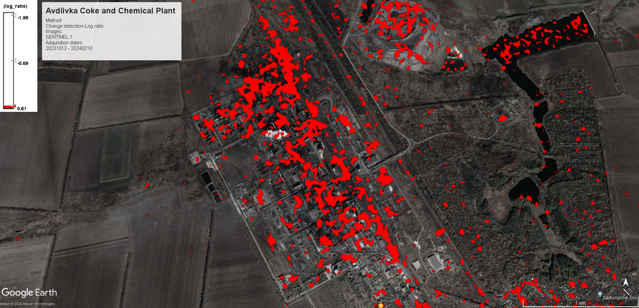
*The changes observed in the images are due to the calculation of the maximum probability of occurrence of the backscattering obtained from the terrestrial elements over the city. These changes are the result of various factors over time, from anthropic changes, such as those generated by war, to natural changes, such as changes in the foliage of vegetation.
In short, satellite imagery proves to be an essential tool in times of war and peace, bringing services to society, from climate change to health hazards, air quality or moving of goods and relief. The space industry technology is expected to evolve, while satellite imagery is set to become even more powerful and important in the years to come, proving to be, in many cases, an enabling technology for various vertical markets and research domains, as well as a source of actionable information for decision making by the private and public sectors.
Read more about the use of space assets in the war in Ukraine
This article is part of a series about the use of space assets in support of the people of Ukraine that we started in the first week of the full-scale war. You can read all articles here.

Article edited by Andrei Bocin-Dumiriu and Vincent Veritas