SAR Helping Turkey and Syria Earthquake Recovery
- Disaster Management Technology
Gabriela Quintana Sánchez
- 0
- 13 minutes read
On 6 February 2023 at 01:17 UTC, a 7.8 magnitude earthquake struck the border between Turkey and Syria, causing loss of life, severe injuries to people, and large scale loss of infrastructure across a large affected region. Right from the moment the earthquake struck, SAR satellite data is helping Turkey and Syria to assess the damage, manage rescue efforts and in the longer term recover from this earthquake disaster.
Currently, more than 34,000 people are confirmed dead and an unknown number still lie trapped under the rubble. The main magnitude 7.8 earthquake shortly after triggered a second earthquake, an aftershock with magnitude 7.5, complicating the situation even further.
About one in twenty earthquakes are followed by a similar-sized or sometimes even larger aftershock within the first week. The magnitude 7.5 did not reduce the chance of further large aftershocks, with already more than 1,000 small aftershocks registered since.
Plate tectonics
The Anatolian Plate is a continental tectonic plate that is separated from the Eurasian plate and the Arabian plate by the North Anatolian Fault and the East Anatolian Fault respectively. Most of the country of Turkey is located on the Anatolian plate. The devastating Turkey–Syria earthquake occurred along the active East Anatolian fault at a strike slip fault where the Arabian plate is sliding past the Anatolian plate horizontally.

It was the deadliest and strongest earthquake to hit Turkey since the 1939 Erzincan earthquake, together with which it is the second strongest in the history of the country since the 1668 North Anatolia earthquake. It was also the deadliest earthquake to have affected Syria since the 1822 Aleppo earthquake, one of the strongest earthquakes ever recorded in the Middle East. Both earthquakes were felt as far as Israel, Lebanon, Cyprus, and the Black Sea coast of Turkey.
Disaster management
In the days following February 6, many research and disaster management institutes have been processing satellite images to understand what happened, identifying the rupture surface, and the magnitude of the displacement generated by the event.
Following Türkiye’s request for assistance to the Union Civil Protection Mechanism (UCPM) on 6 February, 25 European Union Member States and Participating States offered assistance by sending search and rescue and emergency teams.
Less than four hours after the earthquake, the Copernicus Emergency Management Service (CEMS) Rapid Mapping module was activated by the Directorate-General for European Civil Protection and Humanitarian Aid Operations (DG ECHO) on behalf of the Turkish Disaster and Emergency Management Presidency (AFAD) to assess the damage caused by the earthquake.
The Copernicus EMS EMSR648 rapid mapping activation page has all details and maps for rescue and disaster management authorities.
Also read: 10 Years of Copernicus EMS
Using SAR satellite imagery to assess the scale of the earthquake
For example the Centre for the Observation and Modelling of Earthquakes, Volcanoes and Tectonics (COMET) generated the following deformation map, based on the range offsets from pixel tracking, showing us two rupture lines with a length of 250 kilometres, which is considered a catastrophic-level event.

Using SAR range offset map imagery from Sentinel-1, we can calculate the rupture surface of the main 7.8 magnitude earthquake on the main East Anatolian fault in Turkey to be about 300 kilometres long, and an east-west fault that slipped in the 7.5 magnitude aftershock along about 125 kilometres, with a ground displacement in some places of 9 metres.
On the internet we can already find many interferograms of this earthquake, showing range pixel offsets in the affected areas. For example, the interferogram and range pixel offset were generated with the help of the COMET LiCS portal, which allows rapid calculations of ground range displacement. This interferogram is one of the results of a simple DInSAR analysis, in which the measurement made is the phase of the wave. On case of the C-band used in Sentinel-1, this is equivalent to a wavelength of 5.4 cm. The phase is represented by an angle ranging from 0 to 360 degrees.

Groundstation.Space Sentinel-1A SAR data analysis
At Groundstation.space we generated another SAR change detection image of the earthquake in Turkey. Based on Sentinel-1A data (remember, Sentinel-1B is no longer functional) we created a change detection map based on data between January (before) and February 2023 (after), giving us the following image:

In previous articles we talked about change detection using SAR images, being the best tools to extract information about changes that occur in an area of interest over time.
The image is based on two Sentinel-1A images. The first reference image taken on January 29, 2023 and the second on February 10, 2023. Comparing these two data sets using the log-ratio of the areas affected by the earthquake, we can clearly see in red the zone where changes were detected between the two dates in January and February 2023, confirming the affected areas seen in the analyses by COMET.
About the log-ratio comparison method
This is a bit technical, but in the simplest possible terms: the log-ratio is the mean of the backscatter ratio that is observed by comparing the two images, applying a threshold to the decision map and assigning different values to either changed or unchanged pixels.
The log-ration method compares the two SAR images pixel-by-pixel, relying on the consideration that the texture is a zero-mean multiplicative signal. Accordingly, the log-ratio image detector is usually preferable to simple image differencing, which is conventionally used when working with optical data.
Also read: How to interpret SAR image data?
Also read: 5 tips for interpreting satellite images
Also read: Using SAR images for earthquake disaster management
Ongoing rescue efforts
Both earthquakes were the result of a shallow strike-slip fault. More than 34,500 deaths have been reported, and counting: 29,500 in Turkey and 5,000 in Syria. A large winter storm and temperatures plummeting below zero then hampered rescue efforts, dropping snow on the collapsed buildings. Due to the freezing temperatures, survivors, especially those trapped under rubble, are at a great risk of hypothermia. In this situation every minute counts to save lives, and satellite data can bring relevant information to the rescue teams very quickly.
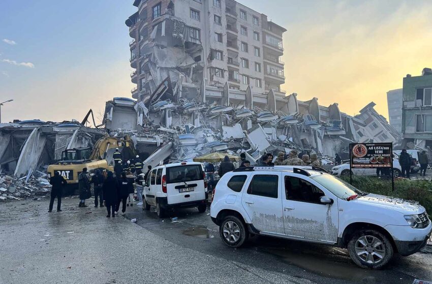
The following pictures were taken in the affected zones.


It is important to remember that obtaining physical parameters of the surface through remote sensing data allows us to save time, costs, and resource-intensive field work, to give us a quick overview of an event in an area of interest. Combining this satellite data with cadastral and census information allows us to very quickly estimate the areas where rescue efforts are most urgently needed, ultimately saving lives. SAR data is proving to be a major source of rapid response information for earthquake disasters, like now in Turkey and Syria.
The scale of this event is horrific and our prayers go out to everyone in the zone affected.
Written by Gabriela Quintana-Sanchez, editing by Remco Timmermans


