Space Technology in Humanitarian Aid: Mapping Crises and Enhancing Response
- CASSINI Technology
Gabriela Quintana Sánchez
- 0
- 18 minutes read

Space technology has emerged as a pivotal tool in humanitarian aid. Space applications contribute significantly to disaster management, crisis response, and international development efforts through their far-reaching capabilities. Integrating Earth observation data, satellite communications, and global positioning technologies enables precise and timely information gathering, aiding in assessing humanitarian crises. Satellite imagery and mapping assist in monitoring urban destruction, refugee settlement growth, and environmental changes around camps. Additionally, space-based resources facilitate early warning systems for natural disasters, enhancing preparedness and response. This invaluable contribution of space technology underscores its crucial role in alleviating the impact of humanitarian crises and fostering global resilience.
Earth Observation and the Humanitarian World
Complex emergencies are also generated by armed conflicts – whether for political, social or religious reasons – or by socio-natural events, which have caused an estimated population displacement of 65 million people by 2015 (UNHCR). In recent years, the use of geospatial technology has increased in applications with humanitarian benefits, such as the following examples:
- Charter International Space and Major Disasters (CHARTER), a global alliance of space agencies, provides satellite imagery services to authorized users to support relief efforts for affected populations and complement domestic capabilities in managing socio-natural disasters.
- Copernicus Emergency Management Service (CEMS), implemented by the European Commission, aims to provide maps and analysis based on satellite imagery (before, during and after a crisis) with operational open access, as well as early warning service and flood and fire risk warning, it should be noted that in the past five years has generated a decrease in the use of CHARTER in Europe.
- United Nations (UNITAR/UNOSAT) provides emergency mapping services based on satellite data, mainly among nations in Africa, Central America, the Caribbean and South America.
- Sentinel ASIA (SA), an initiative of the Asia-Pacific region, is a voluntary collaboration between regional space agencies and disaster management institutions complemented by CHARTER data.
- China National Disaster Reduction Center (NDRCC) provides emergency mapping services based on satellite data.
All these partnerships seek to promote cooperation between space agencies, disaster management services, and end users in the use of space facilities as a contribution to crisis management generated by anthropogenic, technological or socio-natural disasters, thus providing data during the crisis period for crisis management and anticipation, and to support emergency assistance, reconstruction, and subsequent operations.
Despite the availability of geospatial data, the information products derived from it should be sensitive – if they fall into the wrong hands. Therefore, for humanitarian NGOs, the best option is to have their own information service dedicated to the particular tasks that the organization serves.
EUSpace4Ukraine: the EU’s space tool for the Ukrainian people
Satellite Applications in Humanitarian Assistance
Amid urbanisation and conflicts, Synthetic Aperture Radar (SAR) aids in urban destruction assessment, infrastructure identification, and change understanding. SAR vs traditional data is explored via examples like Mosul and Aleppo. Known applications of geospatial data in humanitarian assistance include the following:
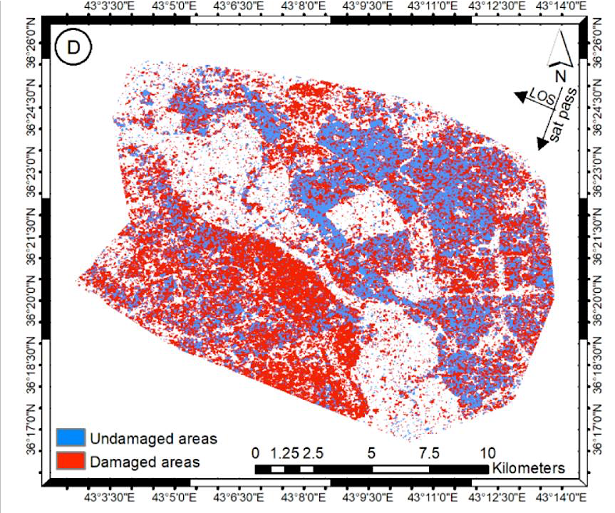
- Monitoring of urban destruction with SAR data, whose purpose is to protect civilians and guide humanitarian response and assistance, in addition to identifying infrastructure affected due to armed conflicts, detecting locations with changes as a result of such conflicts, and thus understanding the strengths and limitations of radar data against traditional data for obtaining information. Below we have two examples of the application of the analysis derived from Radar images in Mosul – Iraq, and Aleppo – Syria, observing the changes in the cities due to the events.

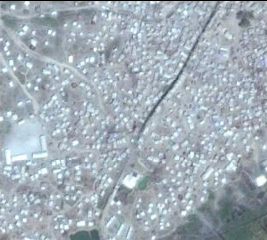
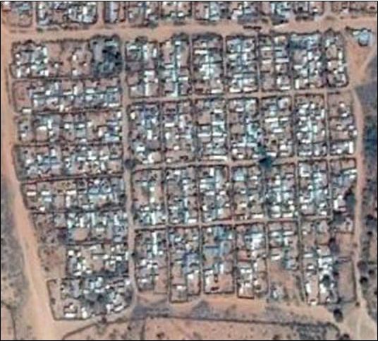
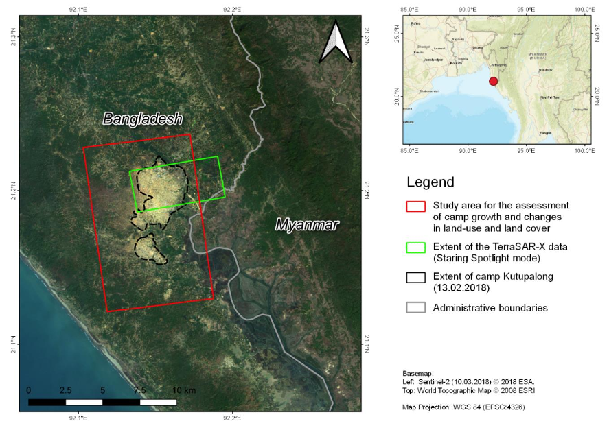
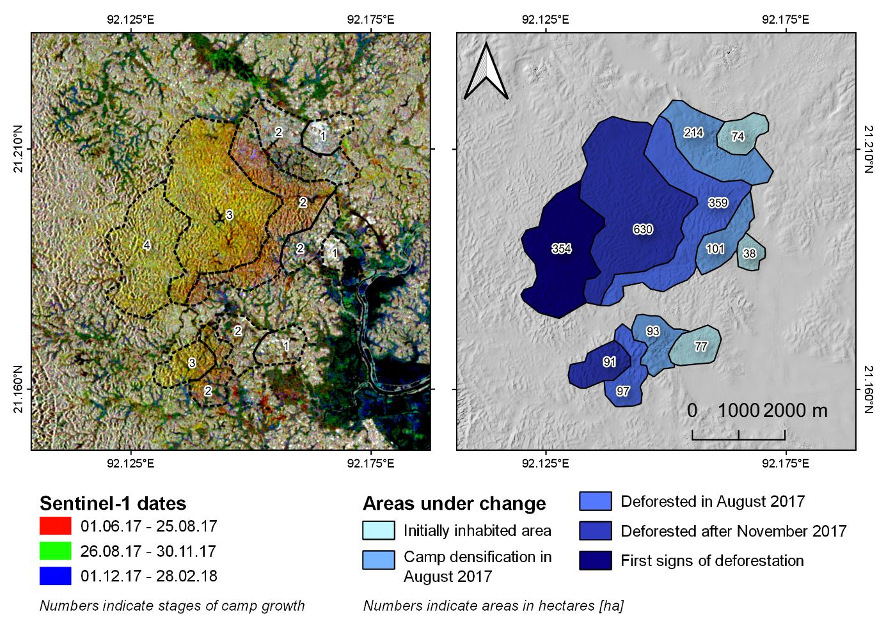
- Mapping growth and changes in refugee settlements, settlement expansion and population growth resulting from refugee arrivals can maintain the availability of resources and the quality and existence of infrastructure. Satellite data can be used to document the timing and rate of change in such settlements and support the estimated refugee population in such settlements. This analysis is intended to examine changes in land use coverage following refugee settlement through qualitative and quantitative time series analysis of the data. Here, we see three examples of this application: the first one tracking the planning of camp growth for better management, followed by the mapping of the Kutupalong refugee camp in Bangladesh (a camp for a minority group of Rohingya Muslim refugees who suffer from ethnic conflicts accompanied by the deprivation of many of their human rights, including their citizenship since the emergence of the conflict in the 1960s), and finally, an example of RGB (Red, Green, Blue) combination to get a quick visualization of the growth of a refugee camp and its subsequent interpretation.
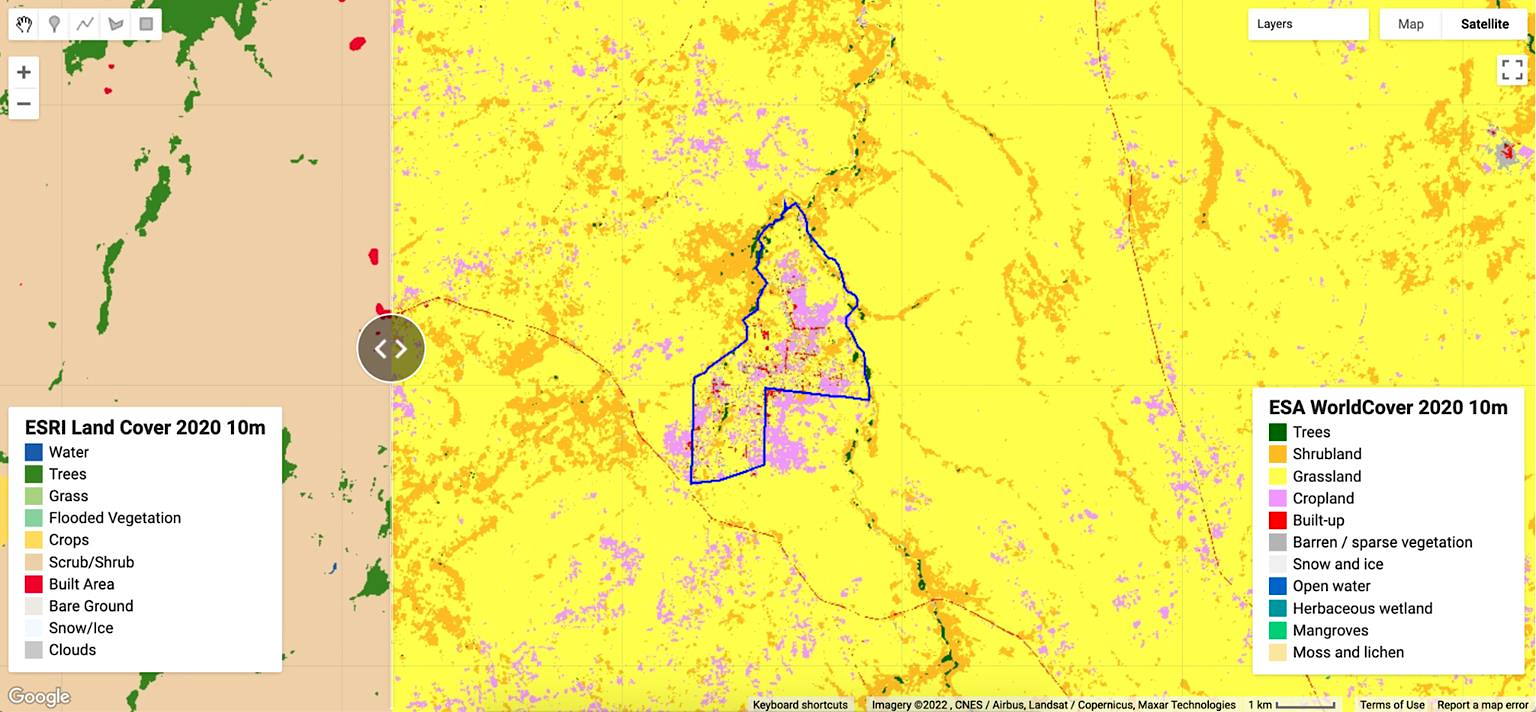
- Detecting agricultural and vegetation changes around refugee camps aims to ensure food security and land quality protection. Because many camps have been uninhabited for years, additional management problems exist. It is, therefore, necessary to monitor land use, agriculture and land degradation around the camps before authorizing new settlements and to monitor their use and changes in their conditions over time. In the following example, we have a land use and land cover map of the Pagirinya Refugee Camp in Uganda, showing polygons of different colours of land use classification in the other areas of the camp.
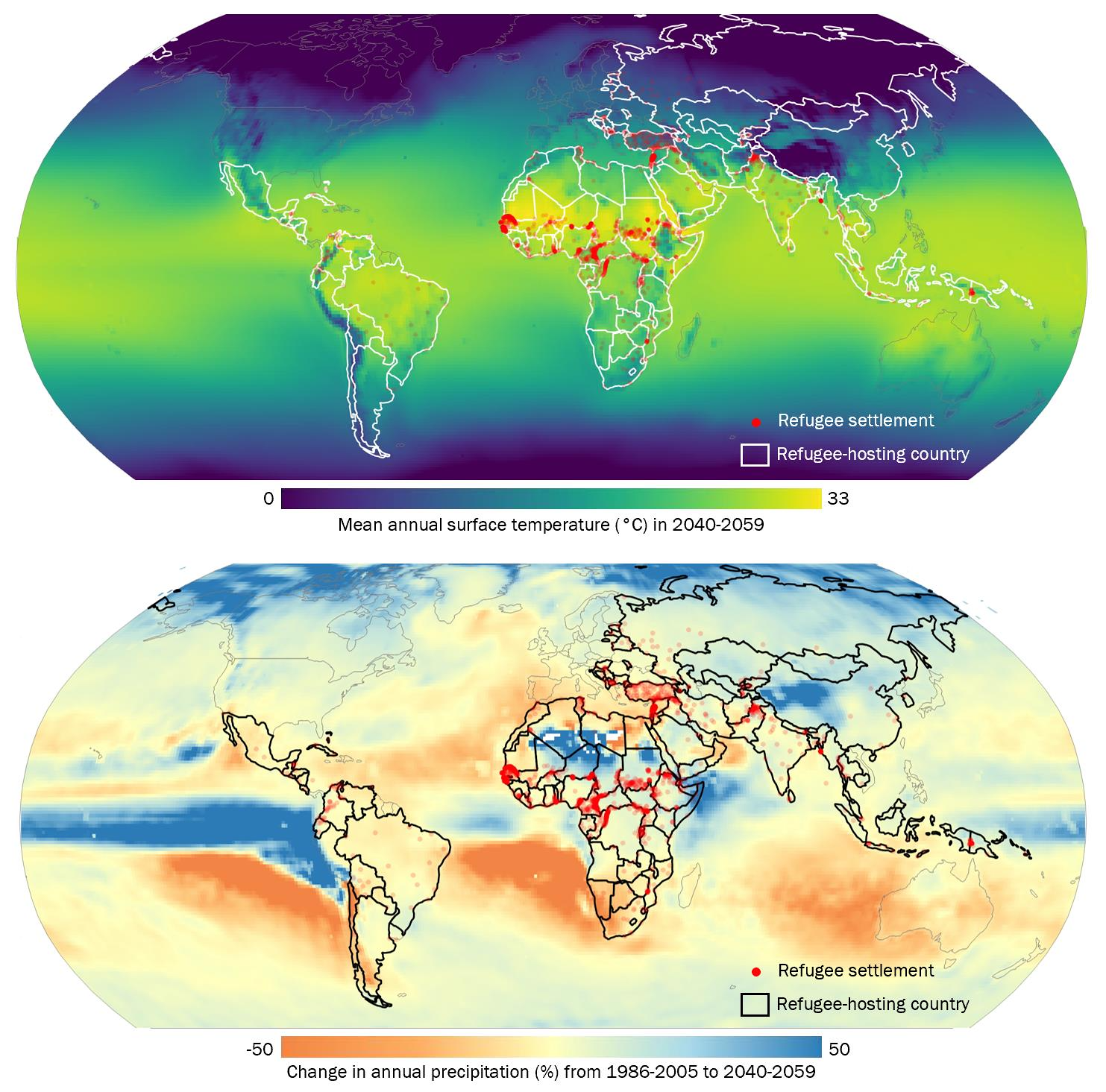
- Assessment of climatic hazards in refugee camps aims to estimate climatic and environmental exposure in support of humanitarian monitoring through multi-criteria analysis of such hazards during multi-site crossings, such as landslides, floods, droughts and heat waves. Such hazards condition the duration of habitation of refugees in a locality, making them doubly vulnerable as they limit migration and communications from authorities.
- Localization of data and information, one of the most common applications of GNSS satellites such as the European Union’s Galileo, has been search and rescue in SAR operations. Galileo’s performance has been enhanced by the European Geostationary Navigation Overlay Service (EGNOS), which acts as Europe’s regional satellite-based augmentation system (SBAS) to improve the performance of global navigation satellite systems—steadily increasing its reach, including deployment to provide safety-of-life (SIL) navigation services to aviation, maritime and land-based users across most of Europe.
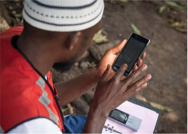
Looking ahead, part of EUSPA’s HARMLESS project aims to promote the use of European GNSS in emergency management, humanitarian aid and law enforcement. This can be seen through tools, such as KoBo Toolbox, based on GNSS satellite data, primary data and information collection, baseline studies, location of activities and location of refugee camp settlement areas in activities related to Humanitarian Aid for vulnerable populations.
The use of geospatial data, whether from satellite, aerial or ground platforms, for emergency use and crisis mapping has increased massively in recent years. As a result of the availability and accessibility of data, as well as increased awareness among humanitarian communities of the benefits of using the technology, we can now expect this proliferation to continue.
Space Solutions for Humanitarian Aid: Join CASSINI Hackathon
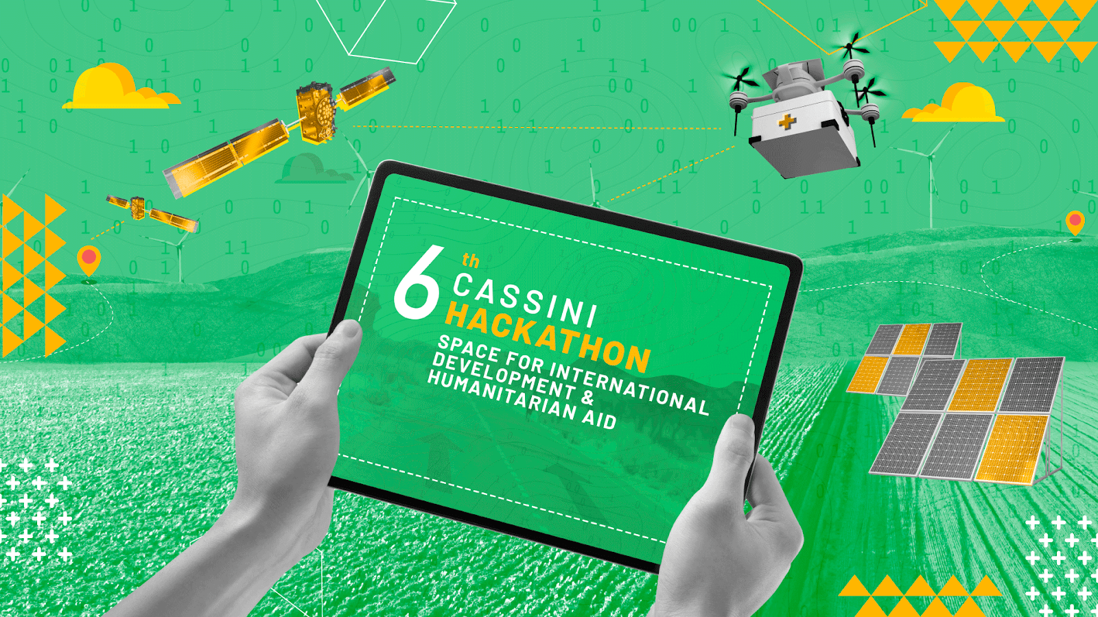
The CASSINI Hackathons & Mentoring programme is an integral part of the European Commission’s CASSINI initiative, which aims to support space entrepreneurship. This initiative consists of a series of six hackathons over three years, specifically designed to leverage space technologies in addressing global challenges. The hackathons bring together a diverse range of individuals, including young professionals, students, researchers, and entrepreneurs with interests in software, data, design, and business. By harnessing the power of earth observation data, satellite positioning technologies, and satellite communications, participants collaborate to create innovative solutions.
We invite you to be part of this exciting journey, where space technology and humanitarian efforts converge. Join us as we tackle global challenges, connect with like-minded individuals, and make a lasting impact on international development. Together, let’s shape a better future through collaboration, innovation, and the power of space technologies.
The 6th CASSINI Hackathon will take place simultaneously across 11 different locations on 3-5 November 2023. dotSPACE foundation and Royal HaskoningDHV are proud to be the local organisers of the 6th CASSINI Hackathon in the Netherlands.

Stay updated
For all the latest about the CASSINI Hackathon, visit our dedicated page regularly. Also, visit the official website of the 6th Edition of the Cassini Hackathon.
References:
Humanitarian Applications Using NASA Earth Observations (2022). National Aeronautics and Space Administration – NASA – Available at appliedsciences.nasa.gov/arset
Braun, A (2019), Radar satellite imagery for humanitarian response Bridging the gap between technology and application. Dissertation der Mathematisch-Naturwissenschaftlichen Fakultät der Eberhard Karls Universität Tübingen. Deutschland.
Article edited by Jerry Yao and Kacia Rutkoūskaja
Featured image credit: Freepik


