How Satellites are Managing Wildfires
- Disaster Management Earth
Kacia Rutkoŭskaja
- 0
- 10 minutes read
Spring and summer are the peak seasons for wildfires. Its consequences can be devastating, ranging from significant loss of forest areas and risks to residential areas, to animal deaths and severe air pollution. One of the best tools to monitor these wildfires are satellites.
Observing Fire from Space
Satellite images and weather data help not only to assess the current situation and the impacted areas, but combined with algorithms, satellite data can also help predict the course of wildfires. This will help firefighters to control the spread of fires and potentially reduce damage.

In northern New Mexico, early-season wildfires continued to rage as early in the season as May. The fires started due to strong winds, low air humidity and dry vegetation. The blaze destroyed hundreds of structures and prompted the evacuation of thousands of homes. Satellites are often the first to detect wildfires in remote regions.
Around the same time, forest fires were also raging in Russia. Greenpeace reports that each year, Russia loses two million hectares of forest as a result of catastrophic wildfires. In contrast to wildfires in the US, Europe and Australia, these massive fires in Russia barely make the international news at all.
DW reported last week that the area of active forest fires in Russia already exceeds 60,000 hectares. The most extensive fires are active in the Krasnoyarsk Territory (35,393 ha), the Irkutsk region (11,855 ha), the Trans-Baikal territory (8,454 ha), Tuva (3,421 ha) and the Tomsk region (1,050 ha).
The Republic of Sakha is one of the most fire-prone regions in Russia. The total forest area in the region is 256.1 million hectares (83.4% of its territory). According to YAKUTIA.INFO, a project has been launched in the Republic of Sakha to more thoroughly monitor forest fires in the region. The “Forest Fires” module of the “Emergency Emergency Monitoring” system, developed in the Republic of Sakha, is an interactive map with operational data on fires. The module includes existing operational programs such as ISDM-Rosleskhoz (information system for remote monitoring of Federal Forestry Agency of Russia) and FIRMS (NASA’s Fire Information for Resource Management System (FIRMS).
Resources for Tracking Wildfires from Space
Recently, GISGeography published three wildfire maps to track real-time fires Around the World. This article mentioned Google Earth Pro as a great tool to use as a base map for overlaying wildfire data from other sources. The two key sources for wildfire data from space are:
1. Copernicus Emergency Management Services CEMS
The Copernicus Emergency Management Services (CEMS) features the European Forest Fire Information System (EFFIS). It uses MODIS (Moderate Resolution Imaging Spectroradiometer) and VIIRS (The Visible Infrared Imaging Radiometer Suite) to track thermal anomalies. EFFIS assesses the burnt area of the forest fire with a polygon extent, as a part of the current situation viewer.
Moreover, EFFIS provides an analysis of seasonal trends and the number of fires in European countries. For fire prevention managers, EFFIS forecasts fire danger levels based on meteorological predictions.

2. NASA WorldView

Active fires maps from NASA can be found via NASA Worldview and NASA’s Fire Information for Resource Management System (FIRMS).
NASA Worldview is a live imagery map, which allows you to see forest fires and (coarse) imagery as they are collected in near real-time.
Better imagery for a basemap provides NASA’s Fire Information for Resource Management System (FIRMS). It is a feature-rich interactive fire map. In this web map, you can visualise daily global fire locations within 3 hours of satellite overpass from both MODIS and VIIRS satellites.
Read More
We regularly report on the use of space data for monitoring wildfires, as one of the key indicators of the climate crisis.
European Wildfire Season from Space
Wildfire Year 2021: Regional Emission Records
Three weeks, twelve Copernicus EMS Wildfire Activations
Do You Know Something We Should Publish About?
Have your say: Opportunities for you to get involved on the Groundstation platform
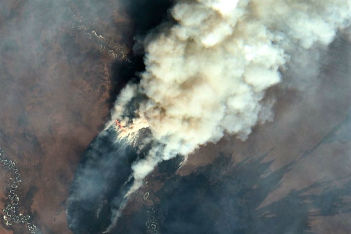
Featured image: Satellite imagery of wildfires in Siberia (Russia) / via Sentinel (ESA)
Authors: Vincet Veritas, Remco Timmermans


