The Battle of Bakhmut Seen From Space
- Technology Ukraine
Gabriela Quintana Sánchez
- 0
- 17 minutes read
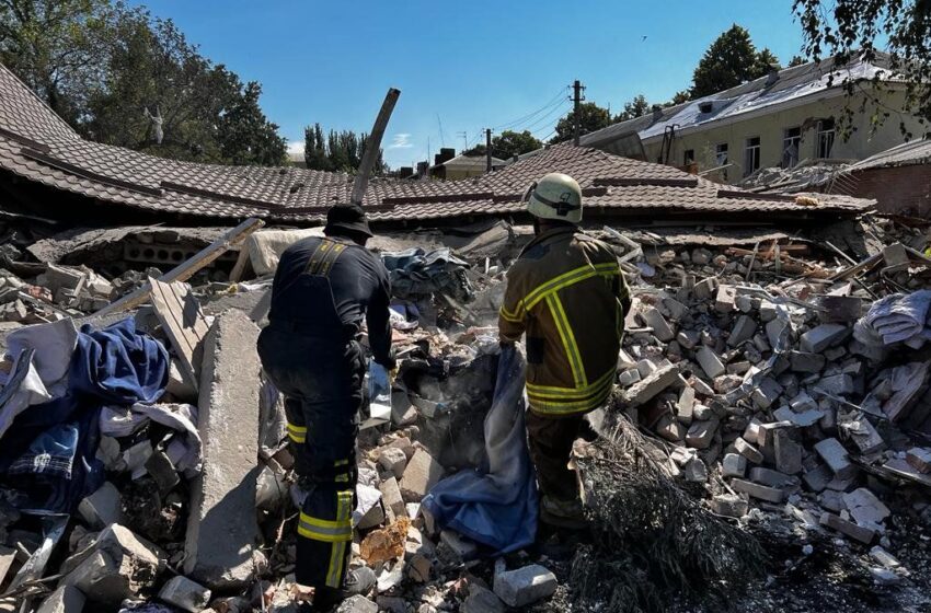
Hotel in Bakhmut after Russian shelling (image: Wikimedia commons)
It has been over a year that Russian troops started the war in Ukraine. The widespread destruction of lives and infrastructure has continued until today, with the battle of Bakhmut as one of the major clashes in the war. Up to the end of March 2023, Ukrainian forces remained in partial control of the Bakhmut city, which has been an epicentre of fierce fighting, as Russian forces battled to take control. Currently the situation remains unclear, but it looks like Russian troops have finally been able to take control.
Bakhmut city is located in eastern Ukraine and was known as Artemivsk in Soviet times. Between the years 1920 and 1924, the city was an administrative centre of the Donetsk Governorate of the Ukrainian SSR. Bakhmut was besieged by Russian forces and largely destroyed, with most of its population having fled, starting around August 2022.
According to Aljazeera News: “Both sides have admitted to suffering and inflicting significant losses in Bakhmut over the past few months, although the exact number of casualties is difficult to independently verify.
Ukraine has repeatedly said that the defense of Bakhmut would continue, with top commanders saying over the weekend the fight there allows them to gain the time needed to prepare a broader counterattack.”

SAR images to monitor war damage
In our long series of articles about ‘space for Ukraine’, which we recently renamed ‘space for defence’, we wanted to investigate the use of publicly available SAR (Synthetic Aperture Radar) data to detect changes on the ground during the battle of Bakhmut.
The European Sentinel-1 satellite has a temporary resolution of 12 days, meaning it is possible to analyse deformation on any location on the planet in 12-day intervals. We have written about the application of change detection techniques for several purposes, like landslides, volcanic activity and earthquakes. We also analysed changes around the Zaporizhzhia nuclear plant, before and after Russian shelling, so we thought we investigate the situation during the long battle of Bakhmut in a similar way.
Selecting Sentinel-1 images
For the analysis we are using 11 Sentinel-1 Ground Range Detected (GRD) images, taken between November 2022 and March 2023, the main period of the battle. The first image in the series, taken on 11 November 2022 serves as the master image. We use the log-ratio change detection method (see a description of different methods in this article) between pairs of images, giving us a moving image of aggregated changes over each 12-day interval during that period.
For our analysis we use data from the mid-range value at mid-orbit altitude, averaged over all swaths (SM/WV) or sub-swaths (IW/EW). For change monitoring we used 11 Sentinel-1 images, of which 8 were useable. Especially snowfall creates some disturbance in a few of the images.
Change detection in 12-day intervals
For our analysis we used the 8 images, showing accumulated changes between 11 November 2022 and 11 March 2023. We overlapped the images over a Google maps image, to show locations of roads and significant building, showing us the change probablity values between -1 (no change) and 1 (change, in red), in the intervals as indicated.
Changes between 11 Nov and 5 Dec 2022

The zones with vegetation surrounding the city have continued changes (alteration in the surface components of the vegetation cover). In the north of the city, we can see a zone with changes, this area is near to Bakhmut railways, and also we can see damage in the railway museum.
Changes between 11 Nov and 29 Dec 2022

In this image, we can see zones with changes between Mariupolska Street, Vulytsya Bakhmut s’ka, Blahovishchenska, Vasylya Pershyna Street, Svobody Street, Lermontova Street, Tsiolkovskoho Ln, and Pryvokzalna Street. The zones with vegetation surrounding the city continue with alteration in the surface components of the vegetation cover, and also plus the damage mentioned in the previous image.
Changes between 11 Nov 2022 and 10 Jan 2023

In this second image, we can see the expansion of the damage to Torgova and Svobody Streets in the middle of the city. Commercial zone of Bakhmut. And to the zone of the Bakhmutovka River east of the city, plus the damage mentioned in the previous image (continue the alteration in the surface components of the vegetation cover).
Changes between 11 Nov 2022 and 22 Jan 2023

Continue the damage southward between the Nezalezhnosti and Myru Streets, plus the damage mentioned in the previous image (continue the alteration in the surface components of the vegetation cover). Much of the infrastructure, buildings, and houses in the city seem to have been damaged in a short amount of time.
Changes between 11 Nov 2022 and 3 Feb 2023

Also in this image, we can see the constant changes between Mariupolska Street and Vulytsya Bakhmut s’ka Street. We continue to see changes in the zones with vegetation and infrastructure.
Changes between 11 Nov 2022 and 15 Feb 2023

New changes in this period here can be seen surrounding Tsiolkovskoho Ln and Pryvokzalna Street and west of the city.
Changes between 11 Nov 2022 and 11 Mar 2023

Many infrastructures, buildings, and green zones in the city have been damaged, this image shows another sharp increase in detected changes in a short time.
How to interpret these change detection images?
There are several misconceptions of how SAR images can be used, as we reported last week. Of course this analysis is an attempt to find out how useable SAR change detection techniques are in discovering damage caused by the war, which is highly likely in this area. Nonetheless there are several other reasons why radar remote sensing detects changes, some of which form the basis of different applications of this technology. These possible causes include:
- Changes in vegetation. Foliage, agricultural crops and weather-related vegetation changes are a large cause for detected changes. This is visible in these images in the areas outside the town, where fields and forests change with the seasons.
- Weather situation. Radar signals are influenced by changes in water heights in rivers and ponds, snowfall on the ground and other changes in weather.
- Ground disturbances with natural causes. Perhaps less relevant here, but earthquakes, volcanic and tectonic activity, landslides and sinkholes cause detectable changes to roads and infrastructure.
- Urban development. Removing old structures and building new will obviously have an impact. Again, not the most likely cause of change in a war zone like Bakhmut.
SAR images as presented above provide no information about the nature of each change detected. It is likely that many of above possible causes all play a role here. We still need other detection methods, like the aerial image up in this article, and reconnaissance on the ground to assess the exact situation. However, SAR change detection can play an important role in selecting areas for further investigation, which is very important in disaster areas, or like here, in dangerous war zones.
Current situation in Bakhmut unclear
Through above images, even when considering the caveats mentioned, we can see the abrupt changes that occurred in the city during the siege of the Russian troops. As early as November 2022, ″The battle of Bakhmut was described as one of the bloodiest battles, with the battlefield being described as a “meat grinder” and a “vortex” by both the Ukrainian and Russian troops. With extremely high casualties, costly ground assaults with very little ground gained″
According to Radio Free Europe/ Radio Liberty on 3 April “Ukraine’s military has disputed claims by Wagner that the Russian mercenary force has captured the center of battle-devastated Bakhmut, and a U.S. official denied the fight for the eastern Ukrainian city was over as Washington said more aid was on the way to Kyiv.
John Kirby, spokesman for the U.S. National Security Council, on April 3 told reporters that the Ukrainian military had not been driven out of Bakhmut, which Russian forces — led by Wagner — have struggled to capture during months of brutal fighting.
He described fighting there as “quite, quite violent and quite close.”
Read more about the use of space assets in the war in Ukraine
This article is part of a series about the use of space assets in support of the people of Ukraine, that we started in the first week of the war. You can read all articles here.
This article was researched and written, and all images created by our SAR remote sensing specialist Gabriela Quintana Sanchez, with editing by Remco Timmermans.


