Monitoring of Infrastructures with DInSAR
- Technology
Gabriela Quintana Sánchez
- 0
- 8 minutes read
The stability of sizeable urban infrastructure can be threatened by different hazards, such as natural processes of the earth’s crust (e.g., volcanic events, earthquakes, landslides, and collapses) and anthropogenic activities (e.g., urban construction, mining activities, oil, and groundwater extraction). Therefore, proper disaster prevention and mitigation must urgently monitor and map the spatiotemporal stability variations of extensive urban infrastructure. Nowadays, we have SAR images as an excellent tool for monitoring these infrastructures’ stability.
In previous articles, we have been talking about the utility of the applications of satellite images for the support of various geoscience studies. With the DInSAR technique, monitoring events from a distance is possible- each day, while new methods help to increase the precisions of the calculation during data processing. The Persistent Scatterer Interferometry (PSI), Short BAseline Subset (SBAS), and SqueeSAR (algorithm for surface displacement detection) techniques are among these advanced methods.
One of the most common methods for monitoring infrastructures is the PSI technique, which uses stable, permanent target scatterer points to determine deformation rates and can effectively reduce the influence of spatiotemporal decorrelations and atmospheric anomalies that affect conventional DInSAR techniques.
Displacement in Thessaloniki International Airport ″Makedonia″
The ongoing subsidence of the area of Thessaloniki in northern Greece has been studied through the years with SAR data from European Remote Sensing Satellite (ERS-1), European Remote Sensing Satellite (ERS-2), Environmental Satellite (ENVISAT), Phased Array type L-band Synthetic Aperture Radar (PALSAR), and SENTINEL-1 together with others measurements. The InSAR technique has monitored surface deformation for the past two decades.
The intense subsidence experienced in the 1990s was previously found to have had a natural surface rebound in the 2000s; for instance, a new period of subsidence caused by the intensification of groundwater overexploitation was reported with a particular concentration in the Makedonia Airport area. Other persistent displacement phenomena driven by anthropogenic activities were observed in regions surrounding Thessaloniki.

Thessaloniki Gulf (image taken from Google Earth)
European Ground Motion Service
The European Union (EU) has developed and maintains a platform for monitoring ground motion- The European Ground Motion Service (EGMS). This free and accessible website provides consistent and reliable information regarding natural and anthropogenic ground motion, with millimetre accuracy, at a continental, national, and local level.

EGMS Platform
The EGMS Basic product provides InSAR displacement data in the satellite radar beam’s line of sight (LOS), with annotated geolocalisation and quality measures per measurement point. Satellite LOS means that measurements are projected along the imaginary line which connects the satellite to the target.
The product is provided as a map of InSAR measurement points, colour-coded by average velocity. A time series plot is associated with each point. The user can consult the product or use it as a base that provides accurate deformation information at a high level of detail or maximum measurement density.
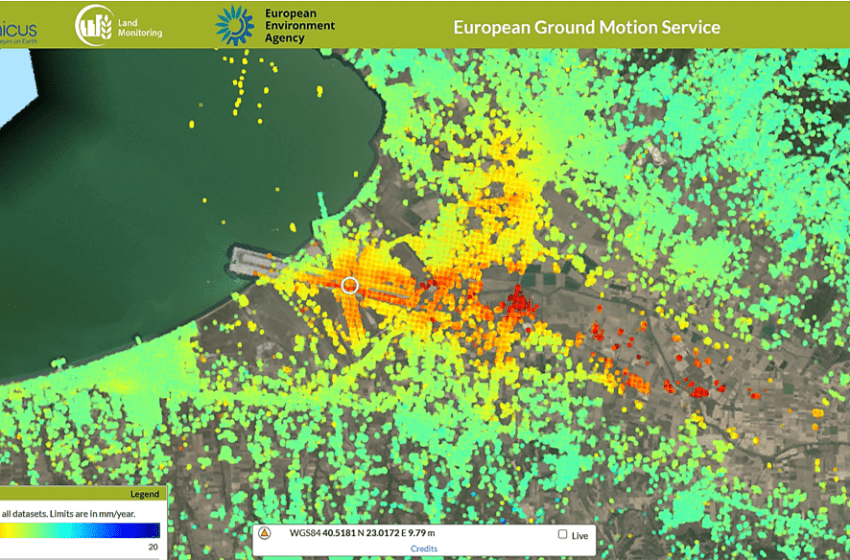
All the products from EGMS are validated information that can be used for the analysis of dynamic phenomena and their evolution, e.g., the displacement in the Thessaloniki International Airport ″Makedonia″ in the vicinity of the coast, southeast of the Thessaloniki Bay (see the following figure). For the analysis of the spatial features of surface motion, clusters of points with similar motion trends can be identified according to the mean velocity, where values of -11.80 mm/year are registered for a period between 20150208 and 20210823.

Land displacement was calculated with SAR Interferometry in Thessalonikis Airport of Greece using the EGMS platform
Thanks to the relatively long time series for terrain displacement solutions in all EGMS products, temporal characteristics and patterns, displacements such as those observed in the Thessaloniki International Airport ″Makedonia″, can be be detected.
The accessibility of different temporal displacements allows the end user to address specific problems, such as geohazard studies, by tracing the evolution of the deformation or projecting trend analyses based on the displacement history.
In conclusion, the EGMS can provide a baseline and facilitate monitoring of urban areas or critical infrastructures like nuclear power plants, chemical storage or refineries, or water gas and power distribution facilities. It is also very useful for detecting subsidence affecting airport runways or port breakwaters. Satellite observations and advanced data processing and interpretation techniques, as well as the use of EGMS products, allow experts to assess differential displacements. Complemented with ground-level tools and techniques that provide detailed asset structural status information, it opens up the possibility of predicting hazards or even planning predictive maintenance.
Read more
This article is part of our series on SAR Remote Sensing Applications.
Article edited by: Jerry Yao, Andrei Bocin-Dimitriu
Featured image: LOS Displacement in Thessaloniki International Airport of Greece


