New NISAR mission to measure climate change
- Technology
Gabriela Quintana Sánchez
- 1
- 9 minutes read
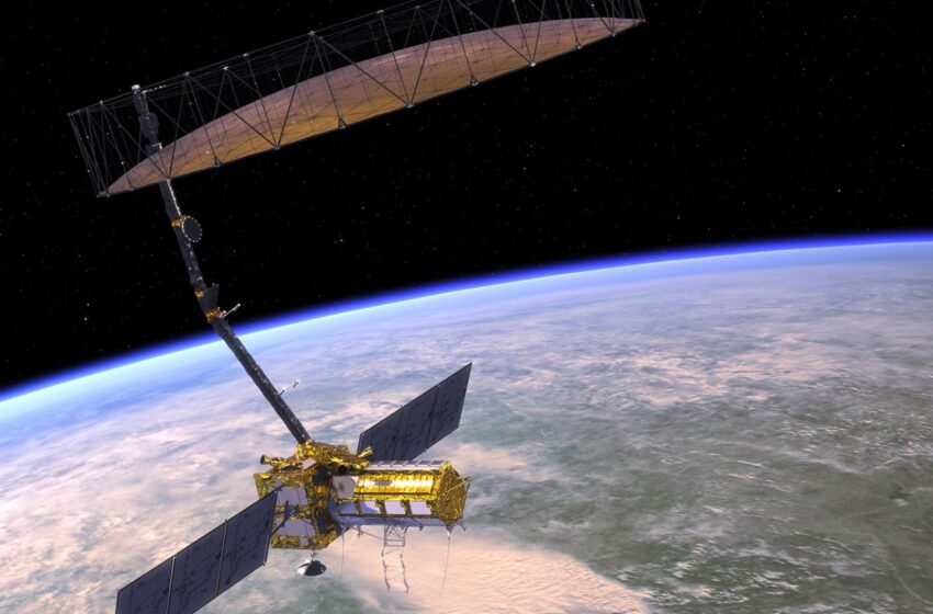
NISAR is a new mission of the US National Aeronautics and Space Administration (NASA) and the Indian Space Research Organisation (ISRO), scheduled to launch in 2023. This new mission will measure Earth’s changing ecosystems, dynamic surfaces, and ice masses providing information about biomass, natural hazards, sea level rise, and groundwater, and will support a host of other applications.
NISAR will observe Earth’s land and ice-covered surfaces globally with 12-day regularity on ascending and descending passes, sampling Earth on average every 6 days for a baseline 3-year mission.
NISAR Mission Goals
The disasters will be directly monitored and assessed for support of emergency response as a mission goal of NISAR, moving beyond the science value provided by better understanding of the processes involved, which can also lead to better forecasting and risk assessment. NISAR mission has the capability to acquire and expedite processing of images in response to disasters, with the redirection of the satellite acquisitions within 24-hours to prioritize downlink, and a special processing stream for the product generation and delivery within 24 hours of acquisition. This urgent response cuts all the NISAR applications areas, such as: forest fire, oil spill, earthquake, major storm, volcanic activity, and catastrophic levee failure.
Mission characteristics
The characteristics of the NISAR mission are:
- Orbit altitude of 747 km
- Orbit inclination of 98.4°
- Repeat cycle of 12 days
- Time of nodal crossing 6AM/6PM
- Orbit control <500 m
- Pointing control <273arcsec
- Pointing Left (south)
- Imaging Swath SweepSAR technique > 240 km
- Polarimetry (Single/Dual/Quad)
- Wavelength L-band (24 cm) and S-band 12 cm)
- SAR resolution 3-10 m mode-dependent
The mission is planned to last at least three years and most importantly, its data and derived products will be available to anyone for free, so it can be combined with any other public satellite data sources into comprehensive products and services that benefit all.
Two radar instruments
The NISAR mission will use two synthetic aperture radar (SAR) instruments, operating at different frequencies to study the Earth. NASA will provide an L-band SAR and ISRO will provide an S-band SAR. NISAR will provide near-global coverage of all land surfaces and many sea ice-covered regions on both ascending and descending orbits of a dawn/dusk sun-synchronous orbit with 12-day revisit period.
Data Products
NISAR data products will be organized by products levels, with Level 0 being raw data with metadata (L0A), and a refined version of the radar signal data with transmission artifacts removed (L0B). L1 products will include all products in radar (range-doppler) coordinates, including the Single Look Complex (SLC), Multi Look Detected (MLD), unwrapped (UNW) and wrapped nearest-time interferograms (IFG), and polarimetric images. L2 products will be geocoded versions of all the L1 products (except MLD and the wrapped interferogram). The NISAR Project Science and Science Teams will generate the L3 products at selected calibration/validation sites distributed globally.
Mission requirements
Level 1 science requirements
The science team has worked with the NISAR project team, ISRO and NASA to develop a set of achievable science requirements. The Level 1 Science Requirements define the specific science measurements that NISAR must perform to satisfy NASA’s and most of ISRO’s science goals. In addition to these joint requirements, ISRO has identified a number of additional Level 1 science requirements that are to be satisfied by the L-band radar instrument. These requirements then flow down to lower-level science and mission requirements that define the scope of the mission development and operations.
The level 1 science requirements will be satisfied by the L-band radar instrument. This sensor will have an accuracy specified as 1-sigma. This refers to the accuracy of backscatter. If the reference area is defined to be the ground, i.e., locally tangent to an ellipsoidal model of the ground surface, then the result is zero-sigma (σ).
The NISAR mission will measure at least two components of the point-to-point vector displacement, with a sampling interval of 12 days or shorter over specified regions of the Earth’s land surface, but if IFG products is available on multiple tracks for the same area of interest, multi geometry data fusion is the best way to gain insight into the 3D surface behaviour of subsurface deformation processes.
Level 2 science requirements
The Level 1 Science Requirements flow down to lower-level science requirements. These Level 2 requirements expand to specific science measurements within each major discipline. While there is formal language associated with each of the Level 2 science requirements, they are listed in detail in tables here, split into the different areas of study of the NISAR mission:
- Solid Earth Science (Earth surface deformation)
- Cryosphere science (ice sheets and glacier movement)
- Ecosystem science (biomass, inundation, agriculture, etc.)
Have said this, we can conclude that the NISAR mission will be the first NASA radar mission to systematically and globally study the solid Earth, the ice masses, and ecosystems by regularly sampling Earth’s land and ice-covered surfaces from ascending and descending orbit vantage points every 12 days.
Join the NISAR community of early adopters
You can still contribute to the further development of NISAR data products and improvement of its services, by subscribing to the NISAR newsletters and a Community of Practice and Early Adopters.

SAR Applications
Read our special series about the many uses of radar satellite data for agriculture, urban management, disaster management and in monitoring the war in Ukraine, at our dedicated SAR pages.


