SAR Satellites for Flood Monitoring
- Disaster Management Technology
Gabriela Quintana Sánchez
- 1
- 8 minutes read

Featured Image by wirestock on Freepik
One of the biggest challenges of climate change is water-related. Flooding of cities is a natural hazard that occurs in many countries worldwide, generating economic, material and human loss. These floods bring misery to those that live in the areas affected. Water can come into people’s houses, pollute drinking water, break down electricity supply, block roads, prevent people from going to work or to school, and causing major damage every year.
Why is SAR better than other remote sensing methods for floods?
SAR satellites use the microwave section of the electromagnetic spectrum. Measuring floods is one of the major application fields of SAR (Synthetic Aperture Radar). SAR sensors have the capability to operate in any weather, as it’s active signal can penetrate clouds and does not depend on illumination by the Sun, so it generates imagery day and night. Additionally, SAR signals are very sensitive to dielectric properties (sensitive to water), permitting a very clear distinction between water and land surfaces.
SAR versus other remote sensing satellites
These characteristics play an important role when selecting the most suitable imaging method for a certain situation, especially for urgent or time-critical observations. SAR is usually the better remote sensing system for tropical regions, that have a relative high cloud coverage, as a consequence of its geographic location, limiting the applications of passive sensors (like optical or infrared sensors).
Within the domain of spaceborne Earth observation, SAR satellites hold a unique position. Not only do they operate at long wavelengths of 1 to 100 cm, which are approximately 100,000 times larger than those of optical measurements, but more importantly they use an active signal. This means that a signal is emitted by satellite, where the returning reflection from the surface back to the radar antenna is measured in order to form an image.
Flood assessment and emergency management
The availability of SAR data in large archives allow flood risks to be assessed over long periods of time, by analysing the inundation frequency of an area within several decades. Besides the retrospective characterisation of flood extents, these large amounts of historic data are integrated in emergency applications, such as the Copernicus Emergency Management Service (CEMS).
Emergency management tools depend on sophisticated automation and constantly improved data integration and comparison methods and models, with a strong focus on risk management, fast damage assessment and crisis response.
Likewise, the International Disaster Charter organisation is a worldwide collaboration through which satellite data are made available for the benefit of disaster management. This organisation combines Earth observation data from different space agencies and commercial providers, allowing rapid coordination of on-the-ground resources and expertise in major disaster situations, where time is always of the essence.
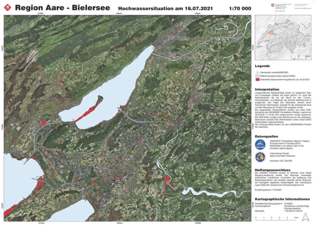
As an example, the following map drawing the flooding of the Region Aare-Bielersee on 16 July 2021. The red contours were extracted from a RADARSAT image, indicating the flooded area, overlaid over an optical image for a better depiction.
Commercial flood monitoring services
Commercial SAR data provider ICEYE announced an agreement with McKenzie Intelligence Services (MIS) for flood hazard analysis using SAR images. This collaboration allowed monitoring of active flood events in support of the generation of property loss information and valuation to the Lloyd’s insurance market, via the MIS Global Events Observer (GEO) platform.
The blue contours were extracted from ICEYE images, indicating the flooded area and, overlaid in a map for a better depiction, showing the affected area and its buildings.
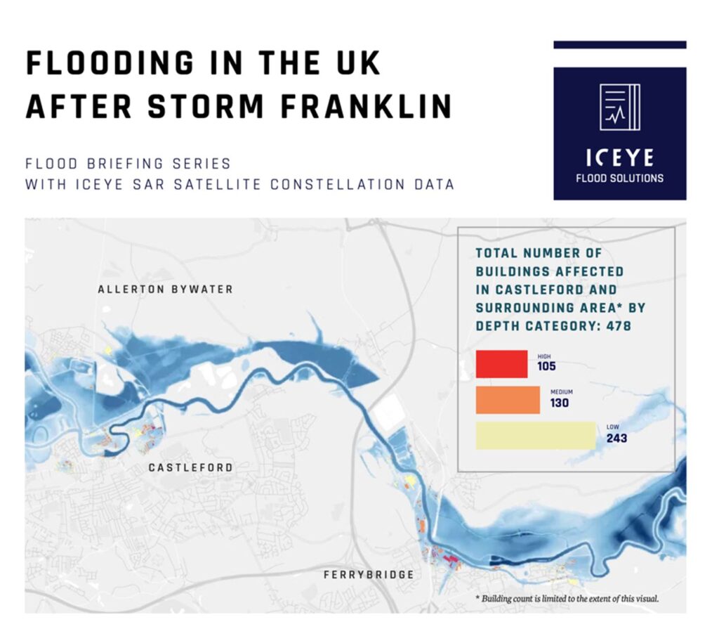
The above case is an example of the capability of the SAR images in the almost real-time monitoring of floodings in cities and the diversity of products that support a rapid emergency response and the associated risk management.
Series about SAR services from space
This article is part of a series of articles about the applications of SAR satellite data. Also read: