Introducing Satellite Data and Career Pathways to Students During NL Space Week
- Education SpaceSUITE
Kacia Rutkoŭskaja
- 0
- 9 minutes read
On 3 October, the Dutch Innovation Factory in Zoetermeer became a place to explore space and satellite data as part of the national Weekend van de Wetenschap and NL Space Week. During an interactive workshop, secondary school pupils and students discovered how satellite data helps make the world smarter, more sustainable and safer.
The workshop Introduction to Satellite Data – Discovering the World from Space was organised in the context of the SpaceSUITE project, which aims to create awareness of downstream space applications and career possibilities, and to introduce young people to the skills and learning pathways needed in the Earth Observation and geo-information sector. The event was organised by the dotSPACE Foundation. The Municipality of Zoetermeer, Dutch Innovation Park, and NL Space Campus provided support through invitations, facilities, and networking activities.

To increase its reach, the half-day workshop was also positioned as part of the Weekend van de Wetenschap and NL Space Week. In the Netherlands, the weekend van de Wetenschap (weekend of Science) takes place every year during the first whole weekend of October. From libraries to businesses and from universities to science parks, all participants open their doors for a unique look behind the scenes in science and technology. The NL Space Week is powered and initiated by NL Space Campus in collaboration with ESA ESTEC and supported by the Dutch space sector. Each organisation organises their own events within the NL Space week context to engage with the public.
From satellite data to real-world questions

How can satellite data help detect forest fires? What can we learn from images of crops, cities and climate change? And how can large volumes of data be translated into solutions for real societal challenges? During the workshop, participants were introduced to the fundamentals of remote sensing and learned how satellites collect data that is essential for agriculture, climate research, disaster response and urban development.
After a short introduction to the space sector, students tested their knowledge in a quiz. When asked about the main players in space, familiar names quickly came up, such as NASA, ESA and Dutch astronaut André Kuipers. The discussion also highlighted the wide range of applications of remote sensing, from climate monitoring to communication and economic analysis.
Working with the Innovative Canvas
The practical part of the workshop focused on teamwork and problem-solving. In small groups, students worked with the Innovative Canvas to develop their own ideas and concepts centred on the use of satellite data. This hands-on approach encouraged discussion, creativity and collaboration between students, teachers and organisers.

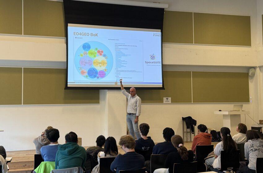
The workshop also introduced participants to the SpaceSUITE Body of Knowledge, a structured framework that helps identify key skills, competencies and learning paths in the Earth Observation and geo-information domain. Through this introduction, students gained insight not only into what satellite data can be used for, but also into how education and training pathways connect to future careers in the downstream space sector.
Creative and practical solutions
The young participants came up with a range of creative and well-thought-out ideas. One group designed a concept to detect methane leaks in oil pipelines using satellite data, highlighting both environmental and economic benefits. Another team proposed a system to locate space debris and ocean waste using magnetic sensors. Other groups explored how Earth Observation data could support housing development, air quality monitoring and greenhouse gas analysis.
Engaging students and teachers
The workshop was attended by more than 30 students from different levels of Dutch education, including VWO (pre-university secondary education), MBO (middle-level applied education) and HBO (higher professional education). Participants came from schools such as Melanchthon Bergschenhoek and Lyceum Zandvliet, and several students are also involved in the national CanSat competition, in which teams build and launch a mini-satellite the size of a soft drink can. Teachers and school representatives joined the session as well.
By actively engaging with real-world challenges and tools, the workshop provided participants with a practical introduction to satellite data and its broad applicability. It also offered an accessible entry point into the world of downstream space applications, education and career opportunities, aligning with the objectives of NL Space Week and the SpaceSUITE project to raise awareness and inspire the next generation.
About SpaceSUITE project

SpaceSUITE is an ERASMUS+ Blueprint project for the development of innovative resources for education and training to bridge the gap between the supply and demand of skills in the ever growing space downstream sector.
SpaceSUITE (Space downstream Skills development and User uptake through Innovative curricula in Training and Education) is grounded on the SPACE4GEO Large-scale Skills Partnership on Space Data, Services and Application under the Pact for Skills and builds on the success and experience of the Erasmus+ Sector Skills Alliance EO4GEO.
This article is based on the original Dutch publication by the event co-organisers. The original article is available here: https://dutchinnovationpark.nl/nl/overzicht/nieuws/de-wereld-vanuit-de-ruimte-ontdekken-tijdens-het-weekend-van-de-wetenschap/